![]()
| From: Gravesend [TQ646743] |
| To: Hastings [TQ827096] |
| Distance: 262km |
The Saxon Shore Way
Location: Kent, East Sussex
OS Maps: Explorer 124, 125, 138, 149, 150, 163
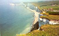 The
Saxon Shore Way, running from Gravesend in Kent round the coast to Hastings
in East Sussex, offers the long distance walker an unrivalled diversity of scenery
from the wide expanses of marshland bordering the Thames and Medway estuaries
to the White Cliffs of Dover, as well as panoramic views over Romney Marsh from
the escarpment that marks the ancient coastline between Folkestone and Rye.
The route is also rich in historical sites and literary associations. Here the
Romans invaded Britain and, later, St. Augustine landed to bring the Gospel
to the Anglo-Saxon kingdom which would later fall to the Normans who, in their
turn, erected great fortresses like Dover Castle to defend their conquests.
The
Saxon Shore Way, running from Gravesend in Kent round the coast to Hastings
in East Sussex, offers the long distance walker an unrivalled diversity of scenery
from the wide expanses of marshland bordering the Thames and Medway estuaries
to the White Cliffs of Dover, as well as panoramic views over Romney Marsh from
the escarpment that marks the ancient coastline between Folkestone and Rye.
The route is also rich in historical sites and literary associations. Here the
Romans invaded Britain and, later, St. Augustine landed to bring the Gospel
to the Anglo-Saxon kingdom which would later fall to the Normans who, in their
turn, erected great fortresses like Dover Castle to defend their conquests.
The Saxon Shore Way was originally opened in 1980, but has since been re-established, and in parts re-routed and extended. It follows the coastline of the South East as it was about 1500 years ago, long before the North Kent Marshes or the Romney Marsh came into existance, when the cliff lines to north and south extended further into the sea and when the Wantsum Channel provided a thoroughfare for boats between the Isle of Thanet and mainland England. The Way takes its name, The Saxon Shore, from a line of fortifications built along the coastline as it was in the 3rd century AD, towards the end of the Roman period. In this time of crisis Saxon invaders came from the southern regions of modern Denmark and in response the Romans built a line of defensive forts along the coast to repel the newcomers.
This long distance path can easily be broken down into daily stages and the guide below gives recommendations for route planning depending upon your particular interests and time available. You may also wish to explore parts of the route at different times and good public transport makes this option viable for most of the route. The Saxon Shore Way links with the 1066 Country Walk at Rye.
| Guide Book: Now out of print | |
 |
The Saxon Shore Way by Bea Cowan. Whether you are walking the path from end to end, or exploring a part of the route, this handy, easy-to-use guide is an indispensable source of advice and information. There are detailed descriptions, including points of interest, for each stage of the path together with 1:25000 Ordnance Survey maps specially prepared to accompany the text. There are colour photographs throughout. Key sites are numbered in the text and on the maps for easy identification. An introductory section gives the historical and geological background to the area. A distance checklist helps you to plan overnight stays and check your progress, and a reference section provides useful addresses and advice on accommodation and transport. This is one of the Ordnance Survey/Aurum Recreational Path Guides which are superbly produced and are everything a good walking guide should be. |
| Tourist information and Accommodation: |
| TIC's are located at Gravesend, Rye, Hastings, Dover and Canterbury TIC information page |
| Services and Public Transport: |
| Kent Public Transport Information Line (0800) 696996 |
| East Sussex Public Transport Rider Service (01273) 481000 |
| Useful links: |