
Walking in Bedfordshire
Bedfordshire does not spring to mind as the county you should seek out for that well earned walking holiday. However, there are many great areas where you will find quiet peaceful countryside offering excellent walking. Bedfordshire may be a small county but has a varied and interesting landscape. So, if you find yourself in Bedfordshire don't despair; you can spend many happy hours discovering its rural charms.
The Great Ouse River meanders through the county, seemingly undecided as to its best course, and the meadows and pastures along its banks can be peaceful places to spend a few hours. Near Bedford the attractive village of Odell and the adjacent Harrold and Odell Country Park provide riverside access and there are lakes and a wildlife reserve between the villages.
The southernmost part of Bedfordshire has the most varied scenery where the Chiltern Hills sweep across the county with their steep escarpment facing north-west, best seen at Dunstable Downs which provides some splendid walking. This chalk escarpment, which runs from the south coast to Norfolk is followed by the ancient Icknield Way, now a long distance path. This path is said to be the oldest road in Britain having been used in prehistoric times by flint traders from the mines at Brandon in Suffolk, known as Grimes Graves.
The Dunstable Downs are the Mecca of British gliding due to the perfect thermal soaring conditions. Nearby is Whipsnade Wild Animal Park with its rare and endangered species.
A little further north is Woburn, sited on a ridge of sandstone running south west to north east, a landscape of pine woods and heathland. Between this ridge and the Chilterns escarpment lies an area of intensive cultivation. In the north east the area around Sandy and Biggleswade is home to many market gardeners exploiting the rich river gravel soils of this region. Water seems to dominate in the pasturelands of northern Bedfordshire where the Great Ouse meanders. This is a peaceful area with quiet, unspoilt villages, many with thatched cottages and stone spire churches. This is relaxing walking country through water meadows edged with willow and Alder and sleepy country lanes.
Rural central Bedfordshire, stretching from the Georgian splendours of Woburn and Ampthill in the west to the old market towns of Sandy and Biggleswade in the east, is an area of gently rolling countryside peppered with woodland, heath and parkland. It is dominated by the Greensand Ridge, which runs from northeast to southwest. The Greensand Ridge Walk meanders through the region.
 Bedford
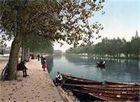 Bedford is an elegant county town renowned for its lace-making, museums
and galleries. John Bunyan, author of Pilgrim's Progress, lived here,
as did US bandleader Glenn Miller during the Second World War. The River
Great Ouse embankment and gardens in the centre of Bedford are very
attractive and provide a relaxing place for office workers and visitors to enjoy a picnic lunch on warm summer days.
Bedford is an elegant county town renowned for its lace-making, museums
and galleries. John Bunyan, author of Pilgrim's Progress, lived here,
as did US bandleader Glenn Miller during the Second World War. The River
Great Ouse embankment and gardens in the centre of Bedford are very
attractive and provide a relaxing place for office workers and visitors to enjoy a picnic lunch on warm summer days.
Woburn
Woburn, situated in picturesque wooded countryside, is an historic village with thatched red and white brick cottages and several old inns. The Bedford Arms was formally a posting-house and has extensive stabling at the back. The village is often frequented by enthusiasts attracted by the Antique Market for which it is well known. Nearby is the famous Woburn Abbey, home to the Duke of Bedford, with its vast parkland containing a wide variety of deer and many other animals. The house has an astonishing collection of important paintings by artists such as Gainsborough, Rembrandt and Van Dyck.
 A Walk from Woburn through the Abbey deer park
[GR SP 951332]
The picture book village of Woburn is well worth visiting, especially
if you are interested in antiques, and provides the start of a lovely
walk around the village and Woburn Abbey. Public footpaths enable you
to stroll amongst the ten different types of deer in the Deer Park as
well as skirt around the formal landscaped grounds surrounding the Abbey,
occasionally passing through woodland or more often walking alongside
one of the many ornamental lakes. Leave the village along the lane towards
the Park and take a path on the right shortly after the church which
will take you to Park Farm and the stables. Follow the track to the
right, enter the Deer Park and continue until you meet a cross track
which is the Greensand Ridge Walk. Follow this eastward past the Abbey
and leave the Park. At a cross path (GR SP978322) turn right following
the Park perimeter until you see a path on your left which re-enters
the Park (GR SP966312). Follow this path through the park following
public right of way signs until you meet the main road. Turn right to
return to Woburn. About 6 miles
Best Pub for this walk
Black Horse, Woburn Tel: 01525 290210 (Good Pub Guide)
The Black Horse, on the main road through Woburn has a charming courtyard
garden. Inside you will find traditional wooded beams and polished floorboards.
An open fire adds to the relaxed atmosphere on cold days. The menu offers
a selection of light snacks in the bar or more formal restaurant dining.
Bar meals range from sandwiches and baked potatoes to steaks and fish
cut to order and grilled in the bar.
List of Bedfordshire Walks
Here is a list of all the 54 walks in the guidebooks listed in the Bedfordshire section of our bookshop. Walk distance and the guidebook in which they appear are also listed.
A= Easy Walking in South Bedfordshire and North Chilterns
B - Walking Close to Bedford
C = Walking Close to Woburn Abbey
| Aldbury and the Bridgewater Monument - 7.5 miles | A |
| Aldbury, Wigginton and Tom's Hill - 7 miles | A |
| Ampthill and Millbrook Warren - 6 miles | C |
| Ashridge Park and Berkhamsted Common - 7 miles | A |
| Ashridge Park and Northchurch Common - 7.25 miles | A |
| Barton-le-clay and Barton Hills - 4.75 miles | A |
| Bow Brickhill Heath and Woburn Estate - 5.5 miles | A |
| Brogborough Hill, Marston Moretaine and Marston Thrift - 10 miles | C |
| Bromham and Bromham Mill - 6.75 miles | B |
| Cheddington, Whistle Brook and Horton - 5.25 miles | A |
| Cholesbury, Buckland Common, Grim's Ditch - 4.25 miles | A |
| Dagnall and Hoo Wood - 6.75 miles | A |
| Dunstable Downs and Whipsnade - 4.75 miles | A |
| Dunstable, Blow's Down and Caddington - 6.5 miles | A |
| Flitwick, Pulloxhill and Flitwick Moor - 5.25 miles | A |
| Gade Valley, Jockey End and Gaddesden - 6 miles | A |
| Grand Union Canal and Wilstone Reservoir - 4 miles | A |
| Great Offley and Botanybay Plantation - 4.75 miles | A |
| Great Ouse Horseshoe and Pavenham - 6 miles | B |
| Hanger Wood and Bromham - 5.75 miles | B |
| Harrold-Odell Country Park and St Nicholas's Church - 8.25 miles | B |
| Ivinghoe Beacon and Incombe Hole - 4.25 miles | A |
| Ivinghoe Beacon and Ridgeway Trail - 4.25 miles | A |
| Markyate, Flamstead and Pepperstock - 6 miles | A |
| Markyate, Holywell and Roe End - 7 miles | A |
| Mill End, Pulloxhill and Sharpenhoe Clappers - 8.25 miles | A |
| Milton Bryan, Hockliffe and Battlesden Avenue - 8.25 miles | C |
| Nettleden and Little Gaddesden - 7 miles | A |
| Old Linslade and Three Locks on the Grand Union Canal - 6.5 miles | C |
| Pegsdon, Hexton and Telegraph Hill - 5.25 miles | A |
| Pinchmill Islands and Sharnbrook - 6 miles | B |
| Piper's Highway and Stevington - 6.75 miles | B |
| Ravensden Brook and Mowsbury Park - 6 miles | B |
| Redbourn Common - 6 miles | A |
| Ridgmont and Briar Stockings - 5.25 miles | C |
| Sharpenhoe Clappers and Markham Hills - 5.25 miles | A |
| Silsoe, Higham Gobian and Wrest Park - 5.5 miles | A |
| Slapton and the River Ouzel - 4.25 miles | A |
| Souldrop and Sharnbrook Tunnel - 6 miles | B |
| Startop's End, Great Seabrook and Marsworth - 8 miles | A |
| Startop's End, Marsworth Top Lock, Little Tring - 6.25 miles | A |
| Studham Common and Beechwood Park - 6 miles | A |
| Tingrith and Witts End - 5.25 miles | C |
| Toddington, Upper Sundon and Chalton - 7.25 miles | A |
| Totternhoe and Doolittle Mill - 6 miles | A |
| Totternhoe Knolls and Maiden Bower - 4 miles | A |
| Tring and Grim's Ditch - 6.25 miles | A |
| Wellbury, Lilley Hoo and Telegraph Hill - 5 miles | A |
| Wilstone Reservoir, Tringford Reservoir, Wilstone - 4 miles | A |
| Woburn and the Safari Park - 6.25 miles | C |
| Woburn Park - 5.75 miles | C |
| Woburn Park, Eversholt and Woburn Abbey - 6 miles | A |
| Woburn Sands and Wavendon Heath - 6.5 miles | C |
| Woburn, Milton Bryan and Potsgrove - 7 miles | C |
| Yelnow Lane and Harrold-Odell Country Park - 6.5 miles | B |
Click here for walking guidebooks to Bedfordshire
© Copyright 2000 - 2023 Walking Pages Ltd. and its associates. All rights reserved