
Walking in Lincolnshire
There's plenty to explore in Lincolnshire; the county is about forty miles wide and seventy miles long with a variety of scenery including fenland, woodland and, of course, the City of Lincoln. Although the county is one of the largest in England, its population density is one of the lowest, so there is plenty of open space and attractive countryside.
The Lincolnshire Wolds
Perhaps the most famous landscape feature of the county, the Lincolnshire Wolds are certainly the best destination for country walking. This forty mile stretch of chalk upland to the west of Georgian Louth is exceptionally pleasing to the eye with scenes of sheep grazing on green rolling hills, deep valleys with hanging beech woods and sunlight glinting on peaceful streams. Much of the Lincolnshire Wolds has been designated an Area of Outstanding Natural beauty.
The Wolds also offer a striking contrast to the flat fenlands, rising to their highest point of 165m near Normanby le Wold with views to the coast, the Humber or the Trent valley. Attractive villages around which to base walks are Somersby (birthplace of Lord Tennyson), with fine views over the Fens; Old Bolingbroke; Tealby and Wold Newton. They mostly seem to be in a time warp; sleepy, tranquil places that the modern world seemed to have no use for. But that's the world's loss, for to those who appreciate the countryside the Lincolnshire Wolds provides idyllic walking.
There is plenty of historic interest to complement the beautiful landscape. Vikings certainly came and settled and farmed here as the many place names ending in ’by’ (meaning farm or settlement) attests. The Viking Way long distance path traverses the Wolds and sections of it can be incorporated into circular day walks. In medieval England the Wolds were also well settled and prosperous due to their fertility, but climate change, famine, the Black Death and changes to farming practices led to many settlements tragically being abandoned. Interestingly you may see evidence of these on your walks in fields that have lots of irregular bumps identifying the locations of these former homes.
South Thoresby
South Thoresby is a small hamlet about 8 miles south of Louth. There are several impressive houses in the village including the old rectory with fine banded brickwork which is opposite the Georgian church.
A Walk from South Thoresby [TF 402768] OS Maps: Explorer™ 274
 This is a rewarding walk around the lower slopes of the Wolds. Springs and streams bubble up from the chalky Wolds and set off towards the coast, and the Great Eau is one stream whose acquaintance you will continually renew. Verdant greenery is all around and herons will no doubt be seen lazily flapping through this land of wood and water. There is much of historical interest including halls and churches, some vanished, some still standing, and a hidden wild man of former heraldic importance. The walk visits the hamlets of Belleau, which means 'beautiful water' and Aby where there are some interesting old cottages and a working smithy. About 4 miles.
Best Pub for this walk
The Vine, South Thoresby Tel: 01507 480273 (Good Pub Guide)
Baskets and tubs of colourful flowers welcome you into this handsome old country inn. The tiniest of bars is flanked by a cosy dining room to one side and a stylish restaurant to the other. The menu contains all the dishes and snacks you would expect, but the specials board offers a few different ideas. Try wild boar in port and red wine sauce or game meatballs on red cabbage. There are tables in a pleasant big garden. The inn is closed on Tuesday and Thursday lunchtimes in winter.
Tealby
 Tealby is an attractive village on the north western slopes of the Wolds with the River Rase flowing past its southern edge after its descent from Bully Hill. Many of the houses in the village are built from local ironstone. The village has associations with Lord Tennyson as his grandfather lived at Bayons Manor which once stood across the Race valley. The Viking Way passes through the village and following the route north to Walesby takes you past the Rambler’s church high on a hilltop before you descend to Walesby. From here you can see the towers of Lincoln cathedral. As a rambler it is worth visiting the church as inside there is a modern stained glass window depicting ramblers and also Jesus, who must have also been a good walker.
Lincolnshire Fens
If you fancy a change from hill walking then the Lincolnshire fenland might interest you. Look at the Ordnance Survey map and you'll be hard pressed to find a height above 10m in this rich, fertile agricultural area. However, you'll also find it difficult to plan a convenient route, as the endless drainage ditches make for difficult passage. The overriding sense one has when walking in this flat landscape is one of big skies. A walk around Boston can give a feel of the Fens, and the town is worth visiting; you can't miss it as the Boston Stump, tower of the magnificent parish church, can be seen for miles. Spalding, during the tulip festival is also a riot of colour in the tulip fields.
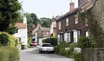
Stamford
The market town of Stamford, located on the River Welland, is a conservation area because of its historical importance. It was the capital of the Fens in Danish times and has many ancient ecclesiastical buildings, the oldest of which is St Leonard's Priory, an 11th century Benedictine house. This led to the town's charter being granted by Henry III in 1254. The town was later a prosperous wool town and several important almshouses were constructed by rich wool merchants including Browne's hospital in Broad Street. Queen Anne houses and elegant Georgian mansions add to the town's architectural pedigree.
Stamford is a pleasant town to stroll around, with its attractive architecture, shops, and restaurants and a couple of interesting museums. The Stamford Museum has a display of cloths worn by Daniel Lambert, supposedly the biggest man in England when he died in 1809 weighing 53 stone (he should have done more walking). The celebrated orchestral conductor Sir Malcolm Sargent is buried in the town cemetery.
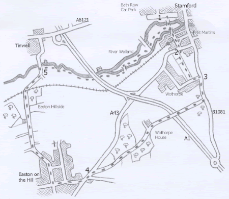
A Walk from Stamford [TF 028070] OS Maps: Explorer™ 234
Park in Stamford at the Bath Row car park (charge payable), or at an alternative car park in the town.
1 Cross the river over the footbridge from the midway point of the car park, walk along the tarmac path and over the next substantial footbridge across the Welland. Keep your direction over the crossroads and up the slope of the street ahead (Wothorpe Road). Go over Kettering Road (the A43) at the T-junction.
2 Go straight ahead at the signpost between the hedge and the railings. Continue through the kissing gate, across the field on a right hand diagonal and through the kissing gate in the opposite corner. Turn left, cross the stile, go uphill and over the stile at the top; turn left and walk up to and across the old Great North Road.
3 Continue uphill to the bridleway sign on the right, turn right along this hardcore track, cross the bridge over the dual carriageway and maintain direction past the farm and through the trees to the A43. Go over the road and turn left.
4 Turn immediate right into Easton-on-the-Hill along the High Street. Take the second right down West Street, follow as it bears left then go right at the fork, signed Byway. Continue downhill over the railway and keep direction along the grass path and walk up to the concrete bridge with iron railings.
5 Do not cross, turn right and walk along the bank with the River Welland on the left. Carry on under the Great North Road, turn left after a quarter of a mile over a footbridge, turn right on the other side back to the original direction but take the path that veers away from the river towards the church spires of Stamford. Keep to the right of the telegraph poles at a fork. The path runs closer to the river again past Roman Ford, carry on to the tarmac path between the footbridges traversed earlier; turn left back to the car park and your vehicle. Distance 5.5 miles
Best Pub for this walk
George of Stamford, High Street, St Martins (B1081)Tel: 01780 750750 (Good Pub Guide)
This pub must be one of the best preserved old coaching inns in England, built in 1597 for Lord Burghley. In the 'pubby' York bar you can get a wide selection of delicious snacks. There is a charming cobbled courtyard at the rear which has comfortable chairs and tables among attractive planting. There is also a very good but expensive formal restaurant.
This walk is taken from the guidebook Walking Close to Stamford by Clive Brown
Click here for walking guidebooks to Lincolnshire
© Copyright 2000 - 2018 Walking Pages Ltd. and its associates. All rights reserved