
Walking in Lancashire
 The M6 motorway provides a physical line which neatly divides Lancashire into its two primary regions. To the west lies the coastal plain with its low sandy beaches between the Ribble estuary and the Cumbria border. This region is often referred to as the 'Lungs of Lancashire' and includes the popular holiday resorts of Blackpool and Morecambe.
To the east of the M6 lies Lancashire's Hill country which is by far the most attractive and interesting for walking. The beautiful countryside in this region embraces the rugged and varied terrain of the Forest of Bowland, a designated AONB, and the secluded open moors in the South and West Pennines. Pendle, famous for its witches, and the Ribble Valley are both great locations for walking in Lancashire. There are stunning views, attractive villages, lovely rivers and streams, woodland, reservoirs, canal side paths and much else to explore and enjoy. The West Pennine Moors is a designated recreational area in the heart of Lancashire. It extends to 90 square miles, comprising of moorland, valleys, wooded cloughs, forestry, farmland and reservoirs.
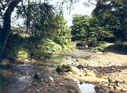
The hamlet of Whitewell has a delightful location nestling under wooded slopes in the Hodder Valley with the moors of the Forest of Bowland as a backdrop and the salmon-rich river flowing through it.
A Walk from Whitewell [SD 659468] OS Maps: Explorer™ OL41
 The immediate surroundings of Whitewell provide a pleasant green oasis surrounded by high moors and this walk links the two contrasting landscapes. The route encircles the slopes to the north and south of Birkett Fell along moorland and field paths that give excellent views of the Bowland Hills in all directions. The route returns along the meandering River Hodder along a path that leads straight to the welcoming door of the Inn at Whitewell. About 6 miles.
Best Pub for this walk
Inn at Whitewell Tel: 01200 448222 (Good Pub Guide)
The delightful riverside location of this inn makes it an idyllic spot for a drink, a meal, or to stay. The riverside bar and the adjacent terrace make the most of the view and the restaurant actually projects over the river. The rooms are impressively furnished and the place has a lovely relaxed atmosphere. This is a true country inn stuffed to the rafters with hunting, shooting and fishing oddities, antiques, paintings and sketches. There is an excellent traditional bar menu with a hearty range of specials that will leave you spoilt for choice, plus an especially large selection of wines if you are dining in the award-winning restaurant. This is definitely a great place to stay, but it is very popular and you will have to book quite away ahead to get a room.
Pendle, Nelson and Colne Area
 Not far north of the industrial town of Burnley lies an enchanting area of surprising beauty and hidden delights. Walk through this scenic landscape and it will unfold to reveal a unique and picturesque corner of Lancashire. Pendle Hill, with its distinctive 1,831 feet profile visible for miles around, provides spectacular views extending north westwards to the Forest of Bowland and west across the Fylde Plain to the Irish Sea.
Rising out of an ancient hunting ground, The Forest of Pendle, the area is characterised by windswept moorland, rocky outcrops, deep-sided valleys (Cloughs) and rolling fields. Steeped in history and legend, Pendle Hill exudes an air of mystery and magnificence. It is believed that the ancient Britons climbed this hill to bury their dead and the Romans worshipped their gods here. Evidence remains of a Bronze Age burial site called the Beacon on top of Pendle Hill.
Superstition and intrigue have also been prevalent here during the early 17th century, when the infamous Pendle Witches, reputed to possess malevolent powers and practice devil worship, put fear in local people. The route they took from their interrogation in Pendle to their conviction and ultimate hanging at Lancaster can be followed on the Pendle Witches Way. On a slightly happier note, the Quaker movement started in Pendle after the founder, George Fox, climbed Pendle Hill in 1652 and had a vision 'of a great people waiting to be enlightened and gathered in'. A good place to start a walk up Pendle Hill is the village of Barley - if you dare!
Weets Hill and Boulsworth Hill There are two other hills in the Pendle area well worth walking. These are Weets Hill just west of Barnoldswick and Boulsworth Hill near Wycoller. Weets Hill is best approached from Barnoldswick and provides a gentle, peaceful walk, with lovely views across Pendle and the Yorkshire Dales. It offers the contrast of vibrant green pastureland, limestone country, and moorland gritstone. A route to Boulsworth Hill from Wycoller Country Park rewards with good views, gritstone outcrops, patchwork fields, wooded valleys and a hidden waterfall.
 Wycoller Country Park The Park, Wycoller village conservation area and the surrounding moors are another glorious walking location in Pendle. The origins of this picturesque village can be traced back beyond 1000BC. There is much of interest to explore here including the ruins of the 16th century Wycoller Hall, a 17th Century aisled barn and the romantic bridges crossing the Wycoller Beck including the Clam bridge, the Clapper Bridge and the Pack-Horse Bridge. There are numerous paths within the park and details can be obtained from the information centre. This is Bronte country and the Bronte Way passes through the village. Charlotte Bronte is thought to have frequently visited Wycoller village in her many walks around the area. The Hall is believed by some to be 'Ferndean Manor' in her novel 'Jane Eyre'. The moorlands roundabout are dominated by tough wiry tussock grasses, heather and purple moor grass. These areas provide excellent habitats for a variety of wildlife including curlew, golden plover and red grouse. The pasture and moorland slopes were once clothed with oak and birch forests, but now woodland is largely concentrated in the stream valleys where you may see a profusion of woodland plants including wood anemone.
The Pendle Way is a 45 mile long distance path which circumnavigates the Pendle region, including the 'Three Peaks'. Parts of it can, of course, be walked as shorter linear walks. The Bronte Way, linking places associated with the family, also passes through Pendle country on its journey to Gawthorpe Hall near Padiham.
Colne The Ferndean Way follows Colne Water from Waterside in Colne to Wycoller. The route is mostly on the level and the path is easily discernible. The walk is approximately 3 miles long and passes areas of interest along the way.
Barrowford The Water Power Trail is a 7 mile circular walk that links some of the early water powered sites found beside Pendle Water. The walk starts at Pendle Heritage Centre. It follows the course of Pendle Water to Brierfield, over to Roughlee and then back to Pendle Heritage centre in Barrowford.
A Walk from Blacko [SD 866413] OS Maps: Explorer™OL21 South Pennines
This is a walk of immense variety and interest through Pendle Witch country. There is a gradual ascent to the moorland by Blacko Tower, then a descent to the secluded valley of Admergill Water following it downstream to the edge of Roughlee and the point where it meets Pendle Water at the local beauty spot of the Waters Meeting. There are splendid views of Pendle and the rugged Pennine moors throughout. About 4.5 miles.
Best Pub for this walk
Cross Gaits Inn, Blacko Tel: 01282 616312
Fresh ingredients and home cooked food, simple snacks and main meals. The Pendle Witches may have been held here and the inn is reputedly haunted, but feels homely and comfortable.
Another excellent inn with good food is the Moorcock on the A682 towards Gisburn. This is a beautifully placed moorland dining pub. (Good Pub Guide).
Ribble Valley
The Ribble Valley is sometimes referred to as the ‘Centre of the Kingdom’. This claim is based upon the fact that the village of Dunsop Bridge in the Ribble Valley was officially declared by the Ordnance survey to be the nearest village to the exact centre of the British Isles.
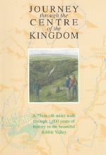 There is a walking route called ‘Journey Through the Centre of the Kingdom’ which is a circular walk around the Ribble Valley starting at Clitheroe Castle. It takes you to a ruined Cistercian abbey, a number of beautiful late medieval churches and the homes of two ‘traitors’. The dramatic history is accompanied by equally dramatic scenery in this beautiful part of the north west. The route, which totals 46 miles is divided into four sections with accommodation available at the start and finish of each section.
Clitheroe, a market town dominated by a large outcrop of limestone upon which stands the Norman Castle and Keep, is the main town within the Ribble Valley. It is an ideal base for a walking holiday in the area, offering plenty of accommodation options and much of interest, including the castle grounds and museum.
Click here for walking guidebooks to Lancashire
Image attribution
© Copyright 2000 - 2018 Walking Pages Ltd. and its associates. All rights reserved