English Counties
Avon
Bedfordshire
Berkshire
Buckinghamshire
Cambridgeshire
Cheshire
Cornwall
County Durham
Cumbria
Derbyshire
Devon
Dorset
Essex
Gloucestershire
Hampshire
Herefordshire
Hertfordshire
Kent
Lancashire
Leicestershire
Lincolnshire
Middlesex
Norfolk
Northamptonshire
Northumberland
Nottinghamshire
Oxfordshire
Shropshire
Somerset
Staffordshire
Suffolk
Surrey
Sussex
Warwickshire
West Midlands
Wiltshire
Worcestershire
Yorkshire
National Parks
Dartmoor
Lake District
Northumberland
Peak District
Bookshop
New
Books
Walking Locations
Long Distance
Walks
Walking Festivals
Post & Packing Charges
Shopping Guide
Contact Us
|
Walking in Leicestershire
 Leicestershire,
part of the North Midlands, is a county of surprisingly varied landscape.
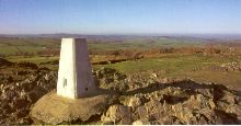
Charnwood Forest is a wild jumble of crags, rocky outcrops, open heathland
and undulating ridges. There is an untamed desolation to the scenery
of this once densely wooded area. The area provides facinating and dramatic
walking amongst the ancient pre-cambrian granite outcrops and remaining
oak woods. There are fine views from the tops of Beacon Hill and Bardon
Hill. Leicestershire,
part of the North Midlands, is a county of surprisingly varied landscape.
Charnwood Forest is a wild jumble of crags, rocky outcrops, open heathland
and undulating ridges. There is an untamed desolation to the scenery
of this once densely wooded area. The area provides facinating and dramatic
walking amongst the ancient pre-cambrian granite outcrops and remaining
oak woods. There are fine views from the tops of Beacon Hill and Bardon
Hill.
However, Charnwood Forest is not typical of Leicestershire's countryside.
It is mostly undulating rich green grazing land on a clay soil, particularly
in southern Leicestershire between Leicester and Market Harborough.
Here there is a network of minor roads winding through the agricultural
landscape and connecting sleepy villages, some of considerable charm;
the Langdons, Hallaton and Horninghold are well worth including in walks.
A particularly attractive feature of the landscape are the numerous
small woods set amongst the undualting fields and hedgerows. These are
not remnants of ancient forest, but were originally planted as fox coverts
by the wealthy landowners who made Leicestershire famous for hunting
with hounds.
A branch of the Grand Union Canal, which connects Market Harborough
with Leicester, passes through some lovely, peaceful open countryside,
making walking routes incorporating part of the towpath very pleasant
on a warm sunny day.
Exton - Exton is a peaceful hamlet with
thatched and honey coloured limestone cottages clustered around a village
green with sycamore trees. Mentioned in the Domesday survey, it's name
means 'ox farm'. It is notable for the fascinating monuments in the
church of St Peter and St Paul, including work by Grinling Gibbons and
for Exton Park with its now ruined Elizabethan Old Hall. The new Hall
is the home of the Noel family, the Earls of Gainsborough, and the estate
has been in this family for over 400 years. The village is not far from
Rutland Water.
OS Maps: Explorer™ 234
A Walk from Exton [SK 925112]
This walk features gently rolling farmland, woodland and two beautiful
lakes, which are set in the grounds of Exton Park, a magnificent privately
owned country estate. There are some fine views to be enjoyed along
the way, together with an air of tranquillity. From the village green
leave Exton via High Street following the Macmillan Way. Continue to
the left of Tunneley Wood and, at the top of a rise with woodland to
the left take a path heading east (GR SK929129). Continue eastward,
eventually dropping down through woodland until you meet North Brook
at the bottom. (GR SK 950129). Cross the stream and descend wooden steps
and follow a path southwards through woodland with the stream to your
right. Soon a beautiful lake will be revealed with an intriguing folly
known as Fort William built in 1788 for Henry Earl of Gainsborough.
Continue past a second smaller lake and follow the path westward which
will take you back to Exton. About 5.5 miles.
Best Pub1 for this walk
Fox and Hounds, Exton Tel: 01572 812403 (Good Pub Guide)
The Fox and Hounds is a 17th century warm and friendly coaching inn
overlooking the village green. The comfortable interior comprises a
public bar, lounge and separate dining area. In winter real fires roar,
while a rose garden or the tranquil village green can be enjoyed on
warmer days. The varied menu includes jacket potatoes, soup, home made
Italian pizza and lasagne, pan fried liver and bacon, rack of lamb with
apricots and rosemary and grilled halibut.
This walk is fully described in the guidebook 'Pub Walks for Motorists
- Northants, Cambs, Leicestershire and Rutland' by Martin Hall
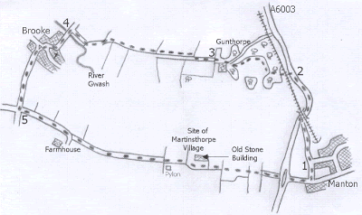
Manton - Manton is another small sleepy village close to Rutland Water and not far south of Oakham.
A Walk from Manton [SK 879045]
1 Walk down the sloping road to the left of the Horse and Jockey past
the sign saying 'No access to Rutland Water'. Go through the gate at
the bottom and turn right under the bridge and along the road. When
the path stops continue along the verge of the A6003 to the bridleway
sign. 2 Turn left, cross the railway and bear right, through an entrance
into the trees. Follow the obvious track through the wood. Turn right
at the exit and keep going around the edge of the field. Go through
the gate in the top right hand corner and along a narrow hedge lined
path opposite; maintain direction through the grounds of Gunthorpe,
making a slight detour to the right at a wall, to a wooden gate. 3 Join
the concrete road on the right and continue direction. Change sides
just past the cattle grid to walk in the right hand field with the hedge
on the left. Keep going along the left hand side of the second field
to the top left corner; go through a tree lined gateway and down the
right hand side of this field. Bear right at the end through a gateway
and down a hedge lined track to a hardcore bridleway. 4 Turn left over
the bridge and into the village of Brooke. Walk past the church up the
slope and turn left at the green triangle, signposted for Uppingham.
Continue uphill to the crossroads and turn left signposted America Lodge.
5 Keep your direction along this bridleway when the tarmac stops, cross
a cattle grid and walk past a pylon. As the information board states
a large house and a village called Martinsthorpe existed here until
the 17th century. Go past the remaining stone building, Old Hall Farm,
to the right. Cross the fence and follow the right hand fence to the
gate; go through and keep direction along the line of trees to the yellow
top post. Continue through the gate and along the bridleway to the road.
Cross the A6003 and walk down the road into Manton and your vehicle.
Distance 5 miles.
This walk is taken from the guidebook 'Walking Close to Rutland Water'
by Clive Brown
When you buy from Walking Pages your complete satisfaction, peace of mind
and security are our main priority. Our on-line bookshop is one of the
longest established on the internet. We have been serving walkers on
line for over six years and have built our reputation on reliable service.
Go to our bookshop by clicking on the 'Books' navigation button or one
of the walking guide links throughout the site and you will be transferred
to our secure server, confirmed by the golden padlock on your browser.
Should you decide to purchase you will be tranferred to HSBC plc. secure
e-payments for credit card transactions, giving you absolute confidence
in your card security. Full information about our terms of trading is
provided at the bookshop.

© Copyright 2000 to 2011 Walking Pages Ltd. and
its associates. All rights reserved
|
|
