English Counties
Avon
Bedfordshire
Berkshire
Buckinghamshire
Cambridgeshire
Cheshire
Cornwall
County Durham
Cumbria
Derbyshire
Devon
Dorset
Essex
Gloucestershire
Hampshire
Herefordshire
Hertfordshire
Kent
Lancashire
Leicestershire
Lincolnshire
Middlesex
Norfolk
Northamptonshire
Northumberland
Nottinghamshire
Oxfordshire
Shropshire
Somerset
Staffordshire
Suffolk
Surrey
Sussex
Warwickshire
West Midlands
Wiltshire
Worcestershire
Yorkshire
National Parks
Dartmoor
Lake District
Northumberland
Peak District
Bookshop
New
Books
Walking Locations
Long Distance
Walks
Walking Festivals
Post & Packing Charges
Shopping Guide
Contact Us
|
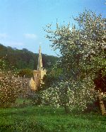
Walking in Somerset
 Part
of the South West peninsular of England, Somerset is a predominantly
rural county and a major holiday destination. It's popularity is hardly
surprising considering the rich mixture of quiet pastoral landscapes,
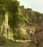
wild moors, stunning limestone gorges and the spectacular northern coastline.
Five ranges of hills, the Mendips, the Quantocks, the Poldens, the Blackdowns,
and the Brendons, provide wonderful walking and spectacular views. South
Somerset is a rural idyll with gentle landscapes, sleepy villages and
colourful beauty in the fields, orchards and woods. The important and
hauntingly beautiful Somerset Levels provides a complete contrast to
the deep and dramatic Cheddar Gorge with its soaring limestone cliffs,
and yet these different landscapes are but a few miles apart. Part
of the South West peninsular of England, Somerset is a predominantly
rural county and a major holiday destination. It's popularity is hardly
surprising considering the rich mixture of quiet pastoral landscapes,
wild moors, stunning limestone gorges and the spectacular northern coastline.
Five ranges of hills, the Mendips, the Quantocks, the Poldens, the Blackdowns,
and the Brendons, provide wonderful walking and spectacular views. South
Somerset is a rural idyll with gentle landscapes, sleepy villages and
colourful beauty in the fields, orchards and woods. The important and
hauntingly beautiful Somerset Levels provides a complete contrast to
the deep and dramatic Cheddar Gorge with its soaring limestone cliffs,
and yet these different landscapes are but a few miles apart.
 The
west of the county is dominated by the magnificent Exmoor National Park,
a walker's paradise. Softer, benign and more compact than Dartmoor,
there is still a feeling of space and wilderness on the open moors.
The many enticing combes through which tumble sparkling streams add
to the walker's delight. Further east the Quantock Hills provide more
splendid walks on a more intimate scale. In the east of the county the
deep limestone gorges and caves of the Mendip Hills provide a stunningly
different landscape. Stone from Mendip quarries was used to build the
magnificent Wells cathedral and many other fine churches in Somerset.
The central and southern areas are a undulating pastoral landscape of
farmland, woods and quiet rivers. For such a small area the landscape
is remarkably varied. Dramatic wooded escarpments drop down to the broad
sweep of the Blackmore Vale and contrast vividly with the flat moorlands
of the rivers Yeo, Ile and Parrett that stretch towards the Somerset
Levels. The Vale of Taunton Deane south of the Quantocks gives a taste
of peaceful, pleasant walking. The
west of the county is dominated by the magnificent Exmoor National Park,
a walker's paradise. Softer, benign and more compact than Dartmoor,
there is still a feeling of space and wilderness on the open moors.
The many enticing combes through which tumble sparkling streams add
to the walker's delight. Further east the Quantock Hills provide more
splendid walks on a more intimate scale. In the east of the county the
deep limestone gorges and caves of the Mendip Hills provide a stunningly
different landscape. Stone from Mendip quarries was used to build the
magnificent Wells cathedral and many other fine churches in Somerset.
The central and southern areas are a undulating pastoral landscape of
farmland, woods and quiet rivers. For such a small area the landscape
is remarkably varied. Dramatic wooded escarpments drop down to the broad
sweep of the Blackmore Vale and contrast vividly with the flat moorlands
of the rivers Yeo, Ile and Parrett that stretch towards the Somerset
Levels. The Vale of Taunton Deane south of the Quantocks gives a taste
of peaceful, pleasant walking.
 To
the south of the Mendips lie the ecologically important Somerset Levels,
one of Europe's most important wetlands. This area, often referred to
as the Plain of Sedgemoor, is a low-lying landscape of willow edged
quiet streams which drain into the rivers Parrett and Brue, which, in
turn, flow into the Bristol Channel. The maze of drainage ditches, or
Rhines, criss-crossing the Levels do not make for easy walking, but
running through the centre of this region are the Polden Hills; although
these are never more than 300ft high they provide the means to walk
and explore this area and provide good views across the Levels to the
north and south. To
the south of the Mendips lie the ecologically important Somerset Levels,
one of Europe's most important wetlands. This area, often referred to
as the Plain of Sedgemoor, is a low-lying landscape of willow edged
quiet streams which drain into the rivers Parrett and Brue, which, in
turn, flow into the Bristol Channel. The maze of drainage ditches, or
Rhines, criss-crossing the Levels do not make for easy walking, but
running through the centre of this region are the Polden Hills; although
these are never more than 300ft high they provide the means to walk
and explore this area and provide good views across the Levels to the
north and south.
Luxborough (Kingsbridge) - Luxborough
is a large parish of scattered hamlets hidden away in the heart of the
Brendon Hills south of Dunster. Kingsbridge is a small hamlet clustered
around a bridge over the Washford River. It is set in a wide green valley.
Steep wooded hillsides descend to lush pastures typical of the Brendons.
Sunken lanes bordered with flowers ramble over the hills, linking the
small settlements within this scattered parish.
OS Maps: Explorer™ OL9
A Walk from Kingsbridge [SS
984377]
This walk follows a woodland path, then a quiet lane to Churchtown,
the oldest hamlet in the parish. Here, the ancient church of St Mary,
high on the southern slope of Croydon Hill, provides glorious views
over Exmoor. The route climbs another sunken track with far-reaching
views over the Washford Valley before descending through woodland to
return to Kingsbridge. The walk leaves Kingsbridge along the Samaritans
Way following the course of a stream. There are carpets of wild daffodils
along here in springtime. On meeting a lane the route descends into
the valley, crosses the stream and climbs to Churchtown. From the church
the route climbs along a sunken lane and follows the hillside before
descending into a narrow valley and turning south returns to Kingsbridge.
About 3.5 miles.
Best Pub for this walk
Royal Oak, Kingsbridge Tel: 01984 640319 (Good Pub Guide)
This delightful pub dates back to the 14th century and has a friendly
and welcoming atmosphere. It is full of character with low beams, inglenook
fireplaces, flagstones in the public bar and two dining rooms. An excellent
menu choice can include shellfish bisque, lamb koftas with mint yoghurt,
grilled rib-eye steak with stilton sauce, or seared Cornish scallops
with coriander pesto. Simpler fare such as baguettes and ploughman's
are also available. There are tables outside for summertime eating.
This walk is fully described in the guidebook 'Pub Strolls in Somerset'
by Anne-Marie Edwards
Yeovil - South
Somerset is mainly a peaceful farming region which has the same unspoilt
rural atmosphere as Dorset. If you want a relaxing walking break in
a landscape of fields, woods, orchards and meandering rivers you could
do much worse than visit South Somerset. Yeovil is the largest town
and provides a good base and shopping, although some of the smaller
market towns are equally convenient for walking and perhaps quieter.
Bruton, Castle Cary, Crewkerne, Langport, and Somerton are particularly
attractive towns. The
area has it's fair share of public footpaths and, armed with an OS map
(Explorer 129), planning interesting routes in this agricultural area
is relatively easy. In additions there are two excellent long
distance trails passing through the region.
 The
Leland Trail is a 45km
route begining at Penselwood (ST 78311) and taking a generally south
westerly direction to finish at Ham Hill Country Park near Montacute
(ST 495167). The landscape is one of dairy and arable farming and passes
through a number of attractive villages. The theme of the route is John
Leland, keeper of the royal libraries under king Henry VIII, who travelled
the route under commission to document England's antiquities. The
Leland Trail is a 45km
route begining at Penselwood (ST 78311) and taking a generally south
westerly direction to finish at Ham Hill Country Park near Montacute
(ST 495167). The landscape is one of dairy and arable farming and passes
through a number of attractive villages. The theme of the route is John
Leland, keeper of the royal libraries under king Henry VIII, who travelled
the route under commission to document England's antiquities.
 The
Liberty Trail, also
about 45km, continues from the end of The Leland Trail at Montacute
and heads south across undulating hills and vales into Dorset and finishing
on the south coast at Lyme Regis (SY 339914). You will need OS Explorer
116 (Lyme Regis and Bridport) for this trail. The theme this time is
supporters of the Monmouth rebellion of 1685 who made the trip to Lyme
Regis to join the Duke of Monmouth in his ill fated campaign. Somerset
is steeped in this facinating period of our history. The
Liberty Trail, also
about 45km, continues from the end of The Leland Trail at Montacute
and heads south across undulating hills and vales into Dorset and finishing
on the south coast at Lyme Regis (SY 339914). You will need OS Explorer
116 (Lyme Regis and Bridport) for this trail. The theme this time is
supporters of the Monmouth rebellion of 1685 who made the trip to Lyme
Regis to join the Duke of Monmouth in his ill fated campaign. Somerset
is steeped in this facinating period of our history.
When you buy from Walking Pages your complete satisfaction, peace of mind
and security are our main priority. Our on-line bookshop is one of the
longest established on the internet. We have been serving walkers on
line for over six years and have built our reputation on reliable service.
Go to our bookshop by clicking on the 'Books' navigation button or one
of the walking guide links throughout the site and you will be transferred
to our secure server, confirmed by the golden padlock on your browser.
Should you decide to purchase you will be tranferred to HSBC plc. secure
e-payments for credit card transactions, giving you absolute confidence
in your card security. Full information about our terms of trading is
provided at the bookshop.

© Copyright 2000 to 2011 Walking Pages Ltd. and
its associates. All rights reserved
|
|
