English Counties
Avon
Bedfordshire
Berkshire
Buckinghamshire
Cambridgeshire
Cheshire
Cornwall
County Durham
Cumbria
Derbyshire
Devon
Dorset
Essex
Gloucestershire
Hampshire
Herefordshire
Hertfordshire
Kent
Lancashire
Leicestershire
Lincolnshire
Middlesex
Norfolk
Northamptonshire
Northumberland
Nottinghamshire
Oxfordshire
Shropshire
Somerset
Staffordshire
Suffolk
Surrey
Sussex
Warwickshire
West Midlands
Wiltshire
Worcestershire
Yorkshire
National Parks
Dartmoor
Lake District
Northumberland
Peak District
Bookshop
New
Books
Walking Locations
Long Distance
Walks
Walking Festivals
Post & Packing Charges
Shopping Guide
Contact Us
|
Walking in Dartmoor National Park
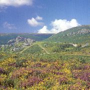 The
wild dramatic landscape of Dartmoor, it's brooding mass dominating South
Devon, is steeped in ancient history and romantic tales. It is the largest
wilderness in southern England, rising to 620m at High Willhays, and
provides a stark contrast to the mild southern coastal resorts. About
half of Dartmoor's area comprises the inner moorland plateau, sliced
in two by the river Dart, where wide, rolling, boggy upland is only
broken by the dramatic and characteristic rocky Tors. The name 'Tor'
comes from the Welsh twr meaning tower, and they certainly resemble
surreal ruined ramparts. In the summer sun the vistas over purple and
yellow heather and gorse are a delight to the eye; in autumn the russet
browns and the eerie mists provoke a more sombre mood. The
wild dramatic landscape of Dartmoor, it's brooding mass dominating South
Devon, is steeped in ancient history and romantic tales. It is the largest
wilderness in southern England, rising to 620m at High Willhays, and
provides a stark contrast to the mild southern coastal resorts. About
half of Dartmoor's area comprises the inner moorland plateau, sliced
in two by the river Dart, where wide, rolling, boggy upland is only
broken by the dramatic and characteristic rocky Tors. The name 'Tor'
comes from the Welsh twr meaning tower, and they certainly resemble
surreal ruined ramparts. In the summer sun the vistas over purple and
yellow heather and gorse are a delight to the eye; in autumn the russet
browns and the eerie mists provoke a more sombre mood.
 The
outer perimeter of Dartmoor has a softer aspect with streams running
through wooded valleys, ancient clapper bridges, winding lanes and farmland.
Some of the grey stone farmhouses are medieval and there are a number
of attractive villages including North Bovey, Drewsteignton and Throwleigh.
Because of its isolation inner Dartmoor has protected and preserved
many prehistoric sites including hut circles, standing stones, burial
chambers and crosses. Many of these ancient structures will be passed
when walking the moors, silent haunting reminders of the many human
feet that have similarly passed by. Dartmoor is also famous for its
wild ponies who are a delightful addition to the scene and who seem
to cope admirably with the vagaries of the climate. The
outer perimeter of Dartmoor has a softer aspect with streams running
through wooded valleys, ancient clapper bridges, winding lanes and farmland.
Some of the grey stone farmhouses are medieval and there are a number
of attractive villages including North Bovey, Drewsteignton and Throwleigh.
Because of its isolation inner Dartmoor has protected and preserved
many prehistoric sites including hut circles, standing stones, burial
chambers and crosses. Many of these ancient structures will be passed
when walking the moors, silent haunting reminders of the many human
feet that have similarly passed by. Dartmoor is also famous for its
wild ponies who are a delightful addition to the scene and who seem
to cope admirably with the vagaries of the climate.
Haytor, with its two separate granite outcrops, is a popular walking
destination with routes included in several of the guides listed below.
From the summit there are stunning views over the surrounding moorland,
the South Devon coast and Teign estuary. Other worthy walking destinations
include Houndtor, Meltor and Sheepstor.
The walker should approach Dartmoor well equipped because its height
and proximity to the coast ensure swift changes in weather including
sudden dense fogs. Navigating in such conditions without a compass is
treacherous, particularly on the high moors where there are large areas
of bog, identifiable by the bright green sphagnum moss which grows there.
Never walk on the open moors of Dartmoor without an OS Explorer map
(OL28) and a compass.
Postbridge - Postbridge is a small village located on the B3212 road almost in the centre of the National Park at an ancient clapper bridge crossing of the East Dart River. This is a remote area and to the north-west of the B3212 are high windswept moors devoid of any roads or human habitation, except for the military. The area around Postbridge was once a tin mining centre and there is also much evidence of prehistoric settlement to be seen.
OS Maps: Explorer™ OL28
A Walk Near Postbridge [SX 674809]
This walk starts at the Warren House Inn, which is about 3 miles north-east of Postbridge. The walk offers a bit of everything; history, archaeology, legend and wild open moorland, with some spectacular views thrown in for good measure. Just north of the Inn at a parking area a track leaves the B3212 on the right, heading east and descending into a valley. After crossing the valley stream and a valley track continue eastwards climbing the southern flank of Birch Tor. The path then descends leading to Headland Warren Farm. On the right you will see a prehistoric stone avenue, many of which appear to be associated with a barrow or burial site. Continue past the farm and climb up to a lane and turn right. Shortly the lane will cross a stream and then you take a path on the left climbing up to the Bronze Age settlement of Grimspound. This is the best preserved ancient settlement on Dartmoor and is well worth exploring. Picking up the Two Moors Way path go north from Grimspound climbing Hookney Tor. From the top there are magnificent views which open up both in front of you to the north and behind you to the south. Keep following the Two Moors Way, climbing Birch Tor with glorious panoramic views to the right and then descend back to the B3212. Turn left to return to the Inn. About 4 miles.
Best Pub for this walk
Warren House, Nr. Postbridge Tel: 01822 880208 (Good Pub Guide)
This remote old tin-miners inn can be a welcome sight after a walk on the moors. The cosy bar has a fireplace at either end and one is said to have been kept continually alight since 1845; to keep the Devil away the story goes. The room is simply furnished with easy chairs and settles under a beamed ceiling. Bar food includes soup, sandwiches, filled baked potatoes, ploughman's, lasagne and home-made steak and ale pie. There are picnic tables across the road that enjoy the moorland views.
This walk is fully described in the guidebook 'Pub Walks in Dartmoor and South Devon' by Michael Bennie
When you buy from Walking Pages your complete satisfaction, peace of mind
and security are our main priority. Our on-line bookshop is one of the
longest established on the internet. We have been serving walkers on
line for over six years and have built our reputation on reliable service.
Go to our bookshop by clicking on the 'Books' navigation button or one
of the walking guide links throughout the site and you will be transferred
to our secure server, confirmed by the golden padlock on your browser.
Should you decide to purchase you will be tranferred to HSBC plc. secure
e-payments for credit card transactions, giving you absolute confidence
in your card security. Full information about our terms of trading is
provided at the bookshop.

© Copyright 2000 to 2011 Walking Pages Ltd. and
its associates. All rights reserved
|
Area 954 square km
Created 1951
|
