English Counties
Avon
Bedfordshire
Berkshire
Buckinghamshire
Cambridgeshire
Cheshire
Cornwall
County Durham
Cumbria
Derbyshire
Devon
Dorset
Essex
Gloucestershire
Hampshire
Herefordshire
Hertfordshire
Kent
Lancashire
Leicestershire
Lincolnshire
Middlesex
Norfolk
Northamptonshire
Northumberland
Nottinghamshire
Oxfordshire
Shropshire
Somerset
Staffordshire
Suffolk
Surrey
Sussex
Warwickshire
West Midlands
Wiltshire
Worcestershire
Yorkshire
National Parks
Dartmoor
Lake District
Northumberland
Peak District
Bookshop
New
Books
Walking Locations
Long Distance
Walks
Walking Festivals
Post & Packing Charges
Shopping Guide
Contact Us
|
Walking in the Peak District National Park
The Peak District
National Park, embracing a southern extension of the England's Pennine
backbone was the first National Park in Britain to be so designated,
in April 1951. Today it is, in visitor numbers, the most popular of
Britain's National Parks and is commonly referred to as the 'lungs of
the industrial Midlands'. More than any other of our National Parks,
the Peak District provides essential recreation for the cities of Manchester
and Sheffield, including great walking in contrasting landscapes.
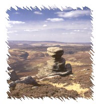 In
parts of it's northern area the Peak District can be a wild, forbidding
place with high peaks at over 600m. This contrasts with the gentler
Derbyshire Dales of the southern area where lively streams splash down
idyllic valleys, Dovedale being the most justifiably famous example.
This contrast is due to the differing geology of the northern and southern
areas. The north, together with the east and west perimeters, comprise
peat moorland and grey millstone grit, predominantly clad in heather
and bracken. This dark brooding appearance has given the area the title
'Dark Peak' and in bad weather it can indeed be a hostile environment.
It can also provide exhilarating walking with spectacular views and
a wonderful sense of freedom. The southern geology is predominantly
limestone, which gives rise to the deep eroded dales and supports a
greener and lighter landscape known as 'White Peak'. In
parts of it's northern area the Peak District can be a wild, forbidding
place with high peaks at over 600m. This contrasts with the gentler
Derbyshire Dales of the southern area where lively streams splash down
idyllic valleys, Dovedale being the most justifiably famous example.
This contrast is due to the differing geology of the northern and southern
areas. The north, together with the east and west perimeters, comprise
peat moorland and grey millstone grit, predominantly clad in heather
and bracken. This dark brooding appearance has given the area the title
'Dark Peak' and in bad weather it can indeed be a hostile environment.
It can also provide exhilarating walking with spectacular views and
a wonderful sense of freedom. The southern geology is predominantly
limestone, which gives rise to the deep eroded dales and supports a
greener and lighter landscape known as 'White Peak'.
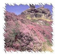 Here
is a region of endless variety and interest that can provide a lifetime's
enjoyable walking. There are idyllic riverside walks, splendid vistas
and the glorious colours of spring wildflowers and summer heather. The
geology is fascinating, from the dramatic limestone cliffs of White
Peak, packed with fossils, to the magnificent gritstone edges with their
strange shapes, so typical of Dark Peak. Archaeologically the region
is also rewarding with fascinating locations such as Gardom's Edge with
its famous rock art, Magpie Mine and the ceremonial monument at Arbor
Low, all of which make good destinations for a walk. Here
is a region of endless variety and interest that can provide a lifetime's
enjoyable walking. There are idyllic riverside walks, splendid vistas
and the glorious colours of spring wildflowers and summer heather. The
geology is fascinating, from the dramatic limestone cliffs of White
Peak, packed with fossils, to the magnificent gritstone edges with their
strange shapes, so typical of Dark Peak. Archaeologically the region
is also rewarding with fascinating locations such as Gardom's Edge with
its famous rock art, Magpie Mine and the ceremonial monument at Arbor
Low, all of which make good destinations for a walk.
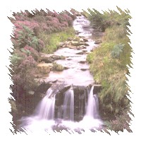 On
bank holiday weekends honeypots like Dovedale, Bakewell and Castleton
become very crowded and are probably best avoided, but it is quite easy
to escape the crowds with a map and walking guide and have relative
solitude in which to absorb the sights and sounds of the countryside.
Within the White Peak area good locations to walk are Lathkill Dale
from Monyash, Thor's Cave from Wetton, Pilsbury Castle, Chatsworth from
Bakewell, Tideswell and Cheedale. There is also easy walking on the
Tissington Trail which follows the trackway of a disused railway. In
the Dark Peak good locations are the Goyt Valley, Stanage Edge, Shutlingsoe,
Win Hill, Kinder South and the Woolpacks, Stanton Moor and The Roaches.
From Edale, of course, you can walk part of the Pennine Way which begins
there. On
bank holiday weekends honeypots like Dovedale, Bakewell and Castleton
become very crowded and are probably best avoided, but it is quite easy
to escape the crowds with a map and walking guide and have relative
solitude in which to absorb the sights and sounds of the countryside.
Within the White Peak area good locations to walk are Lathkill Dale
from Monyash, Thor's Cave from Wetton, Pilsbury Castle, Chatsworth from
Bakewell, Tideswell and Cheedale. There is also easy walking on the
Tissington Trail which follows the trackway of a disused railway. In
the Dark Peak good locations are the Goyt Valley, Stanage Edge, Shutlingsoe,
Win Hill, Kinder South and the Woolpacks, Stanton Moor and The Roaches.
From Edale, of course, you can walk part of the Pennine Way which begins
there.
Hartington - Hartington is an attractive small town close to the River Dove between Buxton and Ashbourne and surrounded by beautiful scenery. Georgian houses built in fawn coloured stone surround a spacious town square, lending a feeling of quiet elegance to the town. The red sandstone church of St Giles with its battlements and curious gargoyles overlooks the town, and on the outskirts Hartington Hall, a youth hostel, once played host to Bonnie Prince Charlie. Hartington is one of only two towns in England that can make genuine Stilton cheese. Nearby Beresford Dale, a beautiful stretch of the River Dove, can be reached via a footpath from the town.
OS Maps: Explorer™ OL24
A Walk from Hartington [SK 128604]
Leave Hartington by a waymarked footpath heading south for Beresford Dale. The opening stages of the path are gravelled and broad, but after crossing a narrow lane it becomes a field path. After passing to the right of Pennilow, a small but attractive hill, the way descends to Morson Wood and the River Dove in Beresford Dale. A footbridge leads over the river by Pike Pool and on the hillside near here you will see a tower that is all that remains of Beresford Hall, once the home of Charles Cotton of fishing fame. The river is re-crossed at Beresford Lane, by a narrow wooden footbridge after which you continue over a broad riverside meadow. At the next footbridge turn you back on the river, ascending a walled lane which diminishes to a footpath. Turn right with the track and left at a metalled road. Turn left onto a waymarked farm track and follow it until you come to another metalled road. Turn left here to return to Hartington. About 3 miles.
Best Pub for this walk
The Devonshire Arms, Market Sq, Hartington Tel: 0129884232 (Good Pub Guide)
Situated in the very centre of Hartington, this attractive old pub offers good food from a choice of simple bar meals which include local specialities such as Hartington Chicken and grilled rainbow trout. The flag-stoned public bar with log fires on colder days welcomes walkers and there are tables out in front facing the village duck pond. Accommodation is available.
This walk is fully described in the guidebook 'Pub Strolls in the Peak District' by Peter Fooks
When you buy from Walking Pages your complete satisfaction, peace of mind
and security are our main priority. Our on-line bookshop is one of the
longest established on the internet. We have been serving walkers on
line for over six years and have built our reputation on reliable service.
Go to our bookshop by clicking on the 'Books' navigation button or one
of the walking guide links throughout the site and you will be transferred
to our secure server, confirmed by the golden padlock on your browser.
Should you decide to purchase you will be tranferred to HSBC plc. secure
e-payments for credit card transactions, giving you absolute confidence
in your card security. Full information about our terms of trading is
provided at the bookshop.

© Copyright 2000 to 2011 Walking Pages Ltd. and
its associates. All rights reserved
|
Area 1438 square km
Created 1951
|
