English Counties
Avon
Bedfordshire
Berkshire
Buckinghamshire
Cambridgeshire
Cheshire
Cornwall
County Durham
Cumbria
Derbyshire
Devon
Dorset
Essex
Gloucestershire
Hampshire
Herefordshire
Hertfordshire
Kent
Lancashire
Leicestershire
Lincolnshire
Middlesex
Norfolk
Northamptonshire
Northumberland
Nottinghamshire
Oxfordshire
Shropshire
Somerset
Staffordshire
Suffolk
Surrey
Sussex
Warwickshire
West Midlands
Wiltshire
Worcestershire
Yorkshire
National Parks
Dartmoor
Lake District
Northumberland
Peak District
Bookshop
New
Books
Walking Locations
Long Distance
Walks
Walking Festivals
Post & Packing Charges
Shopping Guide
Contact Us
|
Walking in Yorkshire
 The
proud inhabitants of Yorkshire once defended their beloved county from
their arch enemies the Lancastrians, during the Wars of the Roses. Its
borders finally succumbed to the vagaries of modern bureaucracy, having
been dissected in the name of progress. A sizable part, North Yorkshire,
remains a county of that name; the rest has become either Unitary or
Metropolitan Authorities. In the interests of common sense we will consider
here the historic Ridings of Yorkshire. None of this, of course, affects
the reality of Yorkshire's magnificent natural landscape, or its unquestionable
claim to contain some of the finest walking countryside in England.
We have yet to meet the rambler who has tired of walking in Yorkshire. The
proud inhabitants of Yorkshire once defended their beloved county from
their arch enemies the Lancastrians, during the Wars of the Roses. Its
borders finally succumbed to the vagaries of modern bureaucracy, having
been dissected in the name of progress. A sizable part, North Yorkshire,
remains a county of that name; the rest has become either Unitary or
Metropolitan Authorities. In the interests of common sense we will consider
here the historic Ridings of Yorkshire. None of this, of course, affects
the reality of Yorkshire's magnificent natural landscape, or its unquestionable
claim to contain some of the finest walking countryside in England.
We have yet to meet the rambler who has tired of walking in Yorkshire.
The gems of the region are the National Parks, the North York Moors
and the Yorkshire Dales, with their very different but equally beautiful
scenery; but Yorkshire's abundant beauty has even more to offer in the
lovely peaceful Wolds north of the Humber and in the Howardian Hills
and Nidderdale, two additional Areas of Outstanding Natural Beauty.
Even all these fabulous areas do not exhaust the possibilities of great
walks as the numerous guide books listed below illustrate so well. For
example the North Yorkshire and Cleveland Heritage Coast offers breathtaking
walks along high cliffs cut by bays and wooded 'wykes' and crowned by
dramatic headlands.
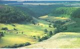
 The
North York Moors National Park contains the largest continuous expanse
of open heather moorland in England. These wild and remote moors have
a wild drama of their own and are home to precious wildlife such as
curlew and merlin. The Park comes to an abrupt end at high cliffs on
the east coast, interspersed with wide sweeping bays and with attractive
fishing villages such as Robin Hood's Bay and Staithes huddled against
the cliffs. Two long distance paths immerse the walker in the glories
of the Moors. The Cleveland Way National Trail follows the northern
perimeter across heather moorland and continues down the Heritage coast;
the Lyke Wake Walk defiantly crosses the highest open moorland from
Osmotherley to Ravenscar. But there are numerous circular day walks
in which you can explore and savour the moors, all of which are included
in the guides listed. The
North York Moors National Park contains the largest continuous expanse
of open heather moorland in England. These wild and remote moors have
a wild drama of their own and are home to precious wildlife such as
curlew and merlin. The Park comes to an abrupt end at high cliffs on
the east coast, interspersed with wide sweeping bays and with attractive
fishing villages such as Robin Hood's Bay and Staithes huddled against
the cliffs. Two long distance paths immerse the walker in the glories
of the Moors. The Cleveland Way National Trail follows the northern
perimeter across heather moorland and continues down the Heritage coast;
the Lyke Wake Walk defiantly crosses the highest open moorland from
Osmotherley to Ravenscar. But there are numerous circular day walks
in which you can explore and savour the moors, all of which are included
in the guides listed.
The delightful, rolling Hambleton Hills, on the edge of the North York
Moors, provide excellent walking country and hold many surprises: the
imposing medieval remains of Rievaulx Abbey and Helmsley Castle; picturesque
villages like Coxwold and Kilburn; landmarks such as the White Horse
of Kilburn, Sutton Bank and Lake Gormire; and surrounding all are miles
of open moorland just waiting to be explored. The Cleveland Hills, with
their rugged, swarthy appearance, stretch from Teeside in the north,
through the Guisborough Moors, to the imposing Cleveland Escarpment,
and beyond to the foot of the Hambletons. The area includes the picturesque
villages of Great Ayton and Osmotherley; hidden valleys like Bilsdale
and Scugdale; and landmarks such as Roseberry Topping.
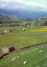
 The
Yorkshire Dales National Park covers a unique area of limestone which
features dramatic cliffs and gorges, the famous limestone pavements
and a landscape of pastoral valleys patterned with dry-stone walls,
barns and stone built villages. There are numerous attractive streams
and waterfalls and, typical of limestone hills, the streams often vanish
into labyrinths of caves, channels and shafts that honeycomb the rock.
On the fells, millstone grit often overlies the limestone, giving a
bleaker, heather-covered aspect to the Park. In late spring and autumn
the fells are a blaze of colour with curlew, snipe, redshank and buzzards
soaring overhead. The lush green meadows of the dales, with their wild
flowers and the clear bright water of the quieter rivers, provide an
inviting contrast to the drama of the fells. Nidderdale is the smallest
of the Yorkshire Dales, between Grassington in the west and Ripon to
the east; Harrogate is at its south-west corner and Middleham is the
northerly point. Within this compact area there are 55 glorious miles
of unspoilt paradise. Lying just outside the Yorkshire Dales National
Park, Nidderdale is a peaceful place to visit, and the upper Dale is
designated as an Area of Outstanding Natural Beauty. The
Yorkshire Dales National Park covers a unique area of limestone which
features dramatic cliffs and gorges, the famous limestone pavements
and a landscape of pastoral valleys patterned with dry-stone walls,
barns and stone built villages. There are numerous attractive streams
and waterfalls and, typical of limestone hills, the streams often vanish
into labyrinths of caves, channels and shafts that honeycomb the rock.
On the fells, millstone grit often overlies the limestone, giving a
bleaker, heather-covered aspect to the Park. In late spring and autumn
the fells are a blaze of colour with curlew, snipe, redshank and buzzards
soaring overhead. The lush green meadows of the dales, with their wild
flowers and the clear bright water of the quieter rivers, provide an
inviting contrast to the drama of the fells. Nidderdale is the smallest
of the Yorkshire Dales, between Grassington in the west and Ripon to
the east; Harrogate is at its south-west corner and Middleham is the
northerly point. Within this compact area there are 55 glorious miles
of unspoilt paradise. Lying just outside the Yorkshire Dales National
Park, Nidderdale is a peaceful place to visit, and the upper Dale is
designated as an Area of Outstanding Natural Beauty.
The Wolds, sweeping in an arc from the Humber Bridge to Bridlington
on the coast, provide a scaled down landscape full of beauty and with
a peaceful backwater atmosphere. There are no towns of any real size
within the Wolds and walking here can be a relaxing tranquil experience
in good weather. The strength of the Wolds lies in the underlying chalk,
for from this bedrock stems its gentleness and boundless charm. Severe
contrasts are rare in this peaceful landscape, where the great appeal
is the subtleness of the harmonies. Between the Wolds and the North
York Moors lie the Vale of Pickering and the market towns of Malton,
Helmsley and Pickering. Just north west of Helmsley in the wooded Rye
Valley stand the splendid ruins of Rievaulx Abbey; the setting and graceful
architecture give a sense of grandeur to this religious site and it
provides the focus for a number of enjoyable walks including a route
from Helmsley.
Wath - Tucked beneath a fold in the surrounding
hills Wath is a small hamlet in Upper Nidderdale, just north of Pateley
Bridge and almost at the foot of the Gouthwaite Reservoir dam. This
is a Conservation village located in a quiet less commercialised area
of the Yorkshire Dales, although Upper Nidderdale is a designated Area
of Outstanding Natural Beauty.
OS Maps: Explorer™ 298
A Walk from Wath [SE 145678]
This walk leaves Wath heading south along the lane out of the village
and then takes Wath Lane on the left at Windy Nook Cottage. The route
begins climbing steeply up the valley side and there are stunning views
back from here north-west looking over Gouthwaite Reservoir. Continue
past a lane on the right then leave Wath Lane, taking a path on the
right near a small conifer plantation. The route descends through the
massive abandoned Scot Gate quarry. Shortly after passing Scot Gate
Cottage turn right along a dismantled railway bed following a sign to
Pateley Bridge. Pass through the town heading for the River Nidd and
then follow the Nidderdale Way northwards along a lovely riverside path
back to Wath. About 3.5 miles.
Best Pub for this walk
Sportsman's Arms, Wath Tel: 01423 711306 (Good Pub Guide)
This 17th century mellow sandstone building next to a river dimpled
with trout is immensely inviting like a favourite grandfather clock.
Buffed and burnished with the smell of beeswax, it ticks on in that
slow and incomparably English way, marvellously archaic wintertime coal
and log fires and candlelight adding to a timeless sense of hospitality.
The food is excellent and they use the best local produce; game from
the moors, fish delivered daily from Whitby, and Nidderdale lamb, pork
and beef. There are seats outside in the pretty garden. Accommodation
is available.
This walk is fully described in the guidebook 'Pub Walks in the Yorkshire
Dales' by Leonard Markham
Redcar and Cleveland - Redcar
is very much the holiday resort of Cleveland. The town has three beaches
and several long rocky reefs jutting out to sea creating a breakwater
which is notoriously dangerous for shipping. Quieter and more attractive
locations for walking in the area are around the small town of Guisborough
with a wide main street with mellow stone buildings and a market cross;
or the fishing village of Staithes with its quaint steep alleyways and
fishermen's cottages. Captain James Cook lived here in a cottage near
the harbour which unfortunately no longer exists. From Staithes, Cowber
Lane leads to Boulby Cliff, two miles west along the coast, and which
at 700ft., is the highest perpendicular cliff in England.
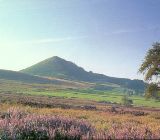
South
west of Redcar lies the pretty village of Great Ayton, nestling at the
foot of the northern ridge of the moors. From the village of Newton,
two miles back towards Redcar you can climb the distinctive Roseberry
Topping. This local landmark, at 1057ft., offers wonderful views of
the North Sea, the valleys and the moorlands and is well worth the climb.
Captain James Cook also lived at Great Ayton, where he went to school.
The monument to Captain Cook on Easby Moor nearby is another landmark
which cannot be missed.
 The
Cleveland Street Walk covers a distance of approximately 11 miles between
the towns of Guisborough and Loftus. Much of the footpath is across
rolling countryside following an ancient track used for centuries as
a right of way. You can begin the walk at either end as there is a frequent
bus service between the two. Known
at times as 'via de Witbei', 'Back Street' and 'Cleveland Street', history
tells us this route was once a major pedestrian highway, probably linking
the priories of Guisborough and Whitby. Its a changed landscape since
the founding of Guisborough Priory in 1119AD; however, with a little
imagination you can picture the monks tending their crops and fishing
the medieval carp ponds to the rear of the priory. At
Slapewath a number of railway branch lines crossed and went to various
mines; the most impressive reminder of this period is the fine eleven
arch Waterfall viaduct, visible through the trees by Spa Wood. Beyond
Slapewath the path rises to give views across to Margrove Park and Charltons.
These villages were of a particularly high quality and housed miners
who worked nearby. The
Cleveland Street Walk covers a distance of approximately 11 miles between
the towns of Guisborough and Loftus. Much of the footpath is across
rolling countryside following an ancient track used for centuries as
a right of way. You can begin the walk at either end as there is a frequent
bus service between the two. Known
at times as 'via de Witbei', 'Back Street' and 'Cleveland Street', history
tells us this route was once a major pedestrian highway, probably linking
the priories of Guisborough and Whitby. Its a changed landscape since
the founding of Guisborough Priory in 1119AD; however, with a little
imagination you can picture the monks tending their crops and fishing
the medieval carp ponds to the rear of the priory. At
Slapewath a number of railway branch lines crossed and went to various
mines; the most impressive reminder of this period is the fine eleven
arch Waterfall viaduct, visible through the trees by Spa Wood. Beyond
Slapewath the path rises to give views across to Margrove Park and Charltons.
These villages were of a particularly high quality and housed miners
who worked nearby.
When you buy from Walking Pages your complete satisfaction, peace of mind
and security are our main priority. Our on-line bookshop is one of the
longest established on the internet. We have been serving walkers on
line for over six years and have built our reputation on reliable service.
Go to our bookshop by clicking on the 'Books' navigation button or one
of the walking guide links throughout the site and you will be transferred
to our secure server, confirmed by the golden padlock on your browser.
Should you decide to purchase you will be tranferred to HSBC plc. secure
e-payments for credit card transactions, giving you absolute confidence
in your card security. Full information about our terms of trading is
provided at the bookshop.

© Copyright 2000 to 2011 Walking Pages Ltd. and
its associates. All rights reserved
|
|
